Support
Contact Us
Menu
Support
Contact Us

by William Tilsley, Imagery Specialist, on 22-Nov-2021 10:18:14

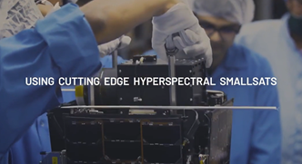
Helping New Zealand see the unseen Pixxel is launching the world's most advanced hyperspectral satellite imaging constellation using cutting edge hyperspectral smallsats capable of 5m resolution and 200+ bands, providing …

Read Story
Topics:Location IntelligenceMaxarGeospatialGovernmentOperational EfficiencyPrimary IndustriesTelecommunicationsSatellite ServicesMappingSatellite DataCouncilsLocal GovernmentRegional GovernmentPixxel

About Critchlow Geospatial

Critchlow Geospatial are Location Intelligence Specialists.

Partnering with world-class solution providers, we enable organisations to see, share and understand information so they make the best business and operational decisions.

More...

Subscribe to Updates