


by Will Tilsley, on 18-Aug-2022 12:50:30
![View over Ashburton River - SI Imaging[81]](https://www.critchlow.co.nz/hs-fs/hubfs/View%20over%20Ashburton%20River%20-%20SI%20Imaging%5B81%5D.png?width=800&name=View%20over%20Ashburton%20River%20-%20SI%20Imaging%5B81%5D.png)
Attractive pricing and vast image library of New Zealand
I’m pleased to announce that SI Imaging Services has joined Critchlow Geospatial’s growing portfolio of carefully curated satellite services providers.
Almost every industry sector in New Zealand will benefit from next generation satellite imagery and its derived data. Critchlow Geospatial has spent the last year hand-selecting international satellite services providers that are able to meet the varied needs of New Zealand’s government and business sectors.
Our goal with this meticulous curation is that our customers will have certainty that we can acquire the types of imagery and data they need, when they need it and, at the right price point.
Why SI Imaging Services?
SI Imaging Services is a leading provider of high-resolution earth observation satellite imagery, data and geospatial information services.
Their mission is to provide “fair access to space” and this fits perfectly with Critchlow Geospatial’s vision of fundamentally democratising access to satellite services in New Zealand through expert curation and strong partner relationships.
Their KOMPSAT (Korean Multi-Purpose Satellite) constellation is a part of the South Korean government’s space development programme. Being an integral part of their national space program means that KOMPSAT’s data continuity is guaranteed (for both optical and SAR).
The constellation is comprised of 4 satellites with resolution that has evolved to 40 cm with KOMPSAT-3A.
What may be of great interest for our customers right now is the vast imagery library - nearly 3,000 images of New Zealand - with very low cloud cover - that have been captured of New Zealand over the last 12 months.
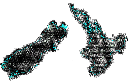
Footprints of all imagery scenes from January 2019 to July 2022 with very low cloud cover, 72% of which is completely cloud-free.
You’ll note from the below table that not only is there excellent coverage of our main centres, but that areas like Southland and Canterbury have a huge amount of current, high-resolution imagery ready to use. Areas of Interest also include territorial waters (12 nautical miles out to sea) for maritime applications.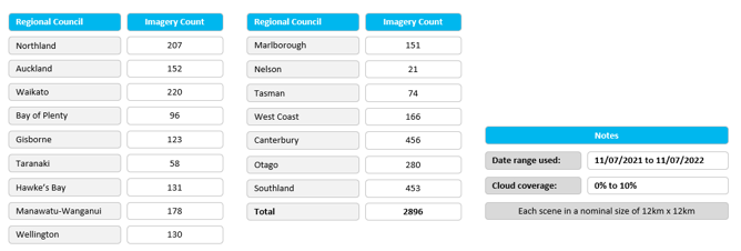
Quick facts about SI Imaging
If you’re acquainted with our novel “satellite services shortlisting tool” (you will find it here), you’ll be familiar with the easy to consume presentation of the metadata. Here are key metrics for SI Imaging: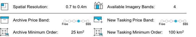
Do you want to see what’s available for your area(s) of interest?
Get in touch with us if you need immediate access to current high resolution (~50 cm), cloud-free (10%) imagery across all of New Zealand or tightly focused urban areas of your choice - and take advantage of attractive pricing and generous licensing for use with up to 5 organisations as standard.
If you want to have a look at what’s available, get in touch.

.png "GL_A GenLess Organisation_WHITE (2)")