


by William Tilsley, Imagery Specialist, on 11-Jul-2022 13:40:48
An educational, on-demand webinar from Capella Space - the industry’s innovation leader - that delves into what SAR satellite data is, how it differs from optical satellite data, and some of its applications.
Optical satellite imagery is the cornerstone of the satellite-based remote sensing industry today and, with continual improvements to resolution, accessibility and expertise, this particular field has flourished.
The same cannot be said of Synthetic Aperture Radar (SAR) satellite data. It is a domain that some geospatial specialists are still unfamiliar with, not having had the opportunity to explore its benefits over optical imagery.
There’s a good reason for that. For decades, the expertise and uses for SAR data have largely been confined to Defense and Intelligence agencies – and hence SAR data had a reputation of principally existing “behind closed doors”.
That’s not true anymore.
New privately owned and SAR-focused satellite companies are emerging, offering spatial images at resolutions not seen before in the SAR field. Most exciting of all is how these new players have swung their doors wide open to other sectors, including government agencies and forestry.
While SAR data accessibility and quality have now been fully unlocked, one of the biggest challenges that still remains is the understanding of what SAR data is and, depending on the use case, how its capabilities are far more powerful than optical satellite imagery. This includes enhanced change detection capabilities and SAR’s ability to penetrate cloud, smoke and darkness.
To give you an idea of this capability, here are two New Zealand examples:
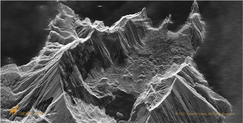
- Whakaari/White Island – taken at 10.00 p.m. on 24 June 2021; and
- Wesport – taken in the late afternoon during a severe weather event with heavy cloud cover last February.
Image: Whakaari/White Island, New Zealand, 24 June 2021, 10:00 pm NZT
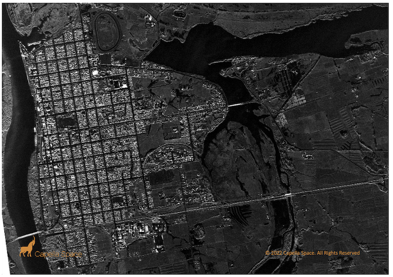
Image: Westport, New Zealand 4 February 2022, 4:27 pm NZT (water displays as black)
Since August 2021, Critchlow Geospatial has partnered with the SAR industry’s innovation leader, Capella Space, to bring their self-service, high-quality , high resolution SAR imagery to the New Zealand market.
Earlier this year, we were delighted to have Jason Brown, Community Enablement Engineer at Capella Space, deliver a well-rounded and thorough introduction to SAR webinar that covered:
- The benefits of SAR
- How it differs from optical imagery
- Applications that leverage Capella Space’s SAR technology

Jason Brown
Community Enablement Engineer
We would like to invite you to watch this webinar and if you have any questions or queries from any of the content, please contact us and we will be happy to answer them.
The webinar recording link will take you to Capella Space’s website. You will need to fill in a few simple details to gain access.
Click here to access the webinar recording.

.png "GL_A GenLess Organisation_WHITE (2)")