


by Steve Critchlow, Group Managing Director, on 20-Jul-2023 11:53:46
.png?width=1156&height=894&name=CC%20BY%204.0%20LINZ%20%E2%80%93%20Cyclone%20Gabrielle%20North%20Island%200.5m%20Satellite%20Imagery%20(21%20February%202023).png) Tasking satellites to capture images of areas impacted by disasters provides exceptional situational awareness. © CC BY 4.0 LINZ – Cyclone Gabrielle North Island 0.5m Satellite Imagery (21 February 2023)
Tasking satellites to capture images of areas impacted by disasters provides exceptional situational awareness. © CC BY 4.0 LINZ – Cyclone Gabrielle North Island 0.5m Satellite Imagery (21 February 2023)
A recent article from management consultancy McKinsey & Company asserts that:
“The space sector is at an inflection point similar to what commercial air travel experienced after World War II and the internet saw in the 1990s. Is your company ready to capture the opportunity?”
I couldn’t agree more that the space sector (in particular, satellite imagery data and technology) is now at its inflection point.
If you are leading a data-driven culture at your organisation, read on to gain an understanding of the importance of satellite imagery data and services for planning and decision-making that are available today to New Zealand public and private sector organisations.
Of late, we have seen some of the strongest use cases for the application of satellite imagery for intelligence gathering and decision-making in the days leading up to and following the recent severe weather events that affected parts of the North Island. Government, insurance and infrastructure organisations, in particular, have been empowered to make better informed decisions thanks to the insights gained from satellite imagery.
In “business as usual” times or when developing transformational programmes of work, this data becomes a critical decision support tool for organisations wanting to protecting New Zealanders’ wellbeing, our economy and our global reputation. Being able to use this data as a long-term record of changes to our natural and built environments is a powerful proposition in itself.
The fact is, whether we are responding to an event or operating in BAU, the opportunity exists right now for New Zealand to access such data and be responsive (and proactive) to our rapidly changing world.
The up-to date situational awareness that only the latest satellite imagery technology can provide enables senior executives to make more informed and data-driven decisions. Whether it's for market analysis, asset management, insurance, site selection, agriculture, or regulatory or risk assessment, having detailed and real-time visual information leads to better strategic choices and cost savings.
Satellite imagery also allows businesses to reduce emissions and operate more sustainably by significantly reducing the need for physical surveys and data collection on the ground (which can be hugely time-consuming and costly).
Today, the global satellite industry understands business, and is meeting their requirements with flexible procurement and acquisition models making it easy to procure and access satellite imagery and derived data in a timely and automated manner.
The space economy inflection point
The application of satellite imagery and its derived data has the potential to unlock societal and economic benefits for New Zealand, and we have now genuinely reached a pivotal moment – the space economy inflection point – when it’s time to act.
Recent severe weather events and natural disasters in New Zealand have proven this.
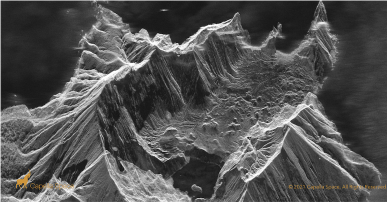 Synthetic Aperture Radar enables one to look through cloud, smoke and darkness of night. Image: Whakaari/White Island, New Zealand, 24 June 2021, 10:00 pm NZT
So, while it’s gratifying to see thought leaders such as McKinsey & Company addressing this issue too, our decision makers need to be bold, swift and decisive if we want to position ourselves to take greatest advantage of this opportunity.
Does your organisation have space strategy?
McKinsey don’t mince their words when they write that space technology is, “at the point where organisational leaders MUST consider its impact and shape their own space strategy”, or they risk being “left on the ground”.
Good news … New Zealand government has released its space strategy in May 2023 where you will find useful information to jump-start your own strategy. The section on Innovation may be providing some jumping off points. as you explore how satellite imagery could be useful (i.e. for creative problem-solving, collaboration and critically, and “driving productivity growth in the economy and improving the well-being of New Zealanders through the innovative applications of space derived data”).
It’s up to New Zealand’s C-suite executives in government and the private sector to incorporate a space strategy into their wider data strategy and roadmap. By embracing this opportunity, New Zealand will be more responsive to our changing world and drive more sustainable growth, leading the way towards a more prosperous and resilient future for all New Zealanders.
If you want to discuss how your organisation and sector could develop your own “space strategy”, incorporating satellite imagery and derived data into your operations, then get in contact with us today – and check out our Satellite Imagery Marketplace, New Zealand's one-stop-shop for satellite imagery and derived data from top global providers.

.png "GL_A GenLess Organisation_WHITE (2)")