


by Steve Critchlow, Group Managing Director, on 13-Jul-2020 12:11:50
Our planet is in a constant state of change; our environment is changing, infrastructure and commerce is always changing, whole patterns of life change.
Throughout the Covid-19 pandemic, satellite imagery has shown us striking views of a world disrupted by social distancing and quarantine measures. The data that can be extracted from satellite imagery can provide some of the deepest insights of our changing world for businesses and government agencies alike.
Satellite imagery from around New Zealand reveals the effects of our management of Covid-19, pre-lockdown, and as we progressed through the alert levels to where we are today.
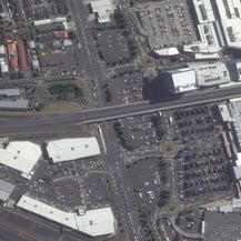
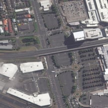
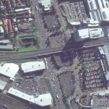
Imagery can be put to good use to estimate retail demand. A common measure of retail activity is counting the number of vehicles in a carpark. Satellite imagery subscriptions make this exercise easy and cost effective, allowing businesses to go back through archival imagery to calibrate turnover versus the number of vehicles in the carpark. To illustrate this, have a look at the 3 satellite images of the number of cars parked outside Auckland’s Sylvia Park taken at 3 different times during our Covid-19 response. With multiple passes per day, there’s plenty of opportunities for standardising the time of day comparisons.
Another example of the analysis of satellite imagery suggests that the coronavirus outbreak may have started earlier in China than in December of 2019. Researchers were looking for indicators of when the novel coronavirus may have first been active in Wuhan. Among other tools, they used high resolution satellite imagery of Wuhan hospital parking lots between January 9, 2018 and April 30, 2020, to estimate hospital visits based on parking lot traffic. The researchers say they found an upward trend in hospital traffic in late summer and early autumn 2019. Read the story here.
We’re only really scratching the surface of what these kinds of extracted datasets will enable governments and businesses to achieve. If you’re ready to understand how this kind of satellite imagery derived data can help your business or organisation – get in touch with us today.

.png "GL_A GenLess Organisation_WHITE (2)")