


by Will Tilsley, on 14-Oct-2020 16:06:50

In a recent study, satellite imagery showed that there has been a large increase in the number of trees felled in European forests, with the forest area harvested each year between 2016 and 2018 being 49% higher than the area harvested each year between 2011 and 2015.
The European Commission Joint Research Centre analysed satellite data that measured the amount of forest cover and area of trees felled across 26 European Union countries.
A rise in tree removal was particularly marked in Sweden and Finland, which accounted for more than half of the total observed increase in harvested area.
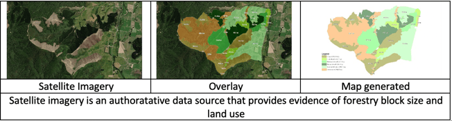
Here in New Zealand, the forestry industry in particular can benefit from the use of multi-spectral, high-resolution satellite imagery. This can be applied in a number of ways for inventory components, such as; tree stocking assessment, Leaf Area Index (LAI) estimation, volume survey and health analysis at stand and individual tree level.
Historically this information could be collected in a direct way through sampling. However, these direct methods are very labour intensive, costly and subject to sampling errors.
The very latest satellite imagery technology and advanced artificial intelligence (AI) offer an affordable solution to this problem. While previous satellite sensors lack sufficient spatial resolution necessary for accurate inventory survey, high-resolution sensors like Maxar’s WorldView-2, WorldView-3 & WorldView-4 satellites with an unprecedented 30 cm – 50 cm spatial resolution are ideal for this purpose.
In addition to this, WorldView-3 has eight spectral bands, providing a better distinction between natural and man-made objects. These advanced capabilities open up a whole new world of opportunities for the forestry industry.
The upcoming Worldview Legion constellation of 6 satellites will provide significantly improved refresh rates for monitoring forestry felling and inventory components mentioned earlier.
Given the large-scale coverage of satellite imagery and low cost of data acquisition, it also offers an affordable solution compared to other existing remote sensing technologies such as manned and unmanned aerial vehicles as well as LiDAR.
If you work in forestry or agriculture, get in touch with us today to understand how the latest satellite imagery and solutions from Maxar and Critchlow Geospatial could help you.

.png "GL_A GenLess Organisation_WHITE (2)")