


by Will Tilsley, on 05-Oct-2022 10:33:02
Affordable, high-frequency, high-resolution imagery captured daily - on a global scale
I'm delighted to confirm another partner addition to Critchlow Geospatial’s carefully curated Satellite Imagery Marketplace – Satellogic.
Satellogic’s comprehensive Earth Observation constellation provides planetary-scale insights so users can find answers, monitor change, and modernise operations with high-resolution satellite imagery at industry-best frequency.
Why Satellogic?
Satellogic virtually reinvented the satellite from the ground up, by creating a smaller, lighter, and more cost-effective system that can be produced at scale. Because of this, Satellogic’s huge constellation offer a highly agile and cost effective offering for rapid tasking and archive.
Indeed, Satellogic is creating a live catalogue of Earth, delivering daily updates on a global scale, to help decision-makers tackle the biggest challenges of our time with a complete picture of the planet.
Satellogic’s Aleph platform makes it easy to securely search their image library, order new captures, and stream or download imagery all via an intuitive web app or API - all with transparent pricing and flexible licensing options.
Quick facts about Satellogic
By 2025, the company expects their 200+ satellites to provide daily remaps of the entire surface of the Earth, with up to 40 revisits of points of interest per day.
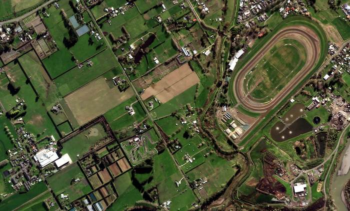
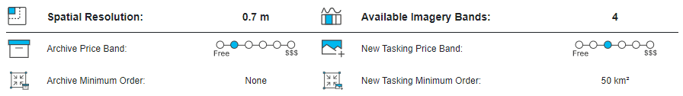
At present, they have 25+ satellites already capable of capturing high-quality imagery (with rapid tasking frequency and response) at 70 cm resolution, perfect for those cases that require a very quick turnaround.
Satellogic prides itself on providing an exceptionally agile and cost-effective approach to Earth observation. The high quality sub-metre data produced by Satellogic is complemented by one of the industry’s most budget friendly price points for both tasking and archive.
Contact us to find out more about Satellogic’s capabilities.![]()

.png "GL_A GenLess Organisation_WHITE (2)")